A fantastic aerial photo from circa 1938 showing old South Portland, from today’s Riverplace area and PSU campus through Duniway Park and the Veteran’s Hospital in the distance. The large industrial complex at lower center is the old Smith & Watson Iron Works, makers of cast iron architectural pieces for many of Portland’s early commercial buildings, as well as fire hydrants that can be found today.
Category Archives: South Auditorium Urban Renewal Area
South Portland Aerial, 1938
This 1938 aerial photo covers much of the heart of the old South Portland neighborhood. Except for some of the area below the inked-in double line, virtually everything here was flattened for the South Auditorium Urban Renewal Project, the Stadium Freeway (I-405) or the PSU campus. One could almost match up this photo with last Friday’s image just a bit south of here.
(City of Portland Archives)
South Portland and Waterfront, 1938
Downtown, 1975
Standing atop the parking garage at SW 1st and Jefferson, we get a good view to the south and a changing Portland skyline of 1975. Newer buildings south of Clay are still standing today, while those north of Clay have been replaced. Notice the tunnels leading under the street where the Marriott Hotel site is being excavated.
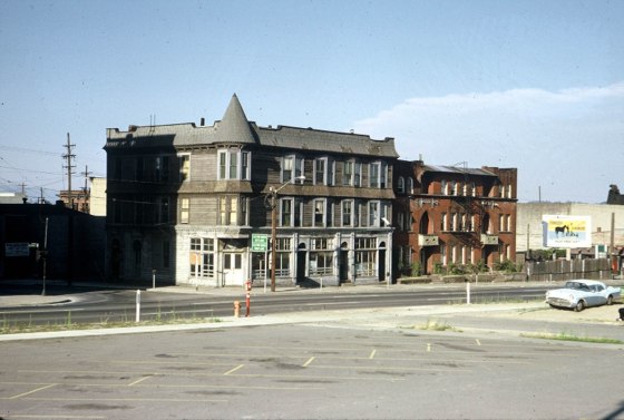
SW 2nd & Market, c1965
These two old rooming houses seem isolated and perhaps even in an industrial area. The truth is, however, that the shadow falling from the left side of the top image is the old Municipal Auditorium and we’re looking northeast at SW 2nd & Market Street. The land behind the photographer had been cleared for South Auditorium Urban Renewal. The area can be seen quite clearly in this earlier VP aerial photo. Thanks again to John for another great photo.
Portland Aerial Panorama, 1965
Portland stretches out from the west side to Mt. Hood in the distance in this nice 1965 aerial photo. It was a dynamic time for the city; I-5 was under construction in Northeast and North Portland and Lloyd Center and the Memorial Coliseum were recently completed. On the west side, the South Auditorium Urban Renewal District had leveled South Portland but demolition had not yet begun for I-405. The Marquam Bridge piers take shape crossing the Willamette.
Unknown Location, c1961 – Help Us Out!
Let’s clear the weekend cobwebs with a Monday brain teaser. Your mission is to find this location; the date on the photo is circa 1961 and the address on one of the fourplex doors on the left appears to be “127” or “137.” All these houses have seen better days and chances are they didn’t survive the last half century but I’ve been fooled before. The finder of this location is indeed a VP master sleuth. Happy hunting!
Found: SW 2nd & Grant


