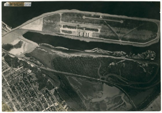
Portland’s rudimentary Swan Island Airport is clearly illustrated in this 1939 top-down photo. It was common in those days of unsophisticated instruments to paint the city name on a roof so early pilots knew they had the right (or wrong) airport. Except for rail lines, Mocks Bottom appears to be completely undeveloped at this time.
Vintage Portland


To me, it was a big mistake to have developed this area into semi-industrial. Would have been a beautiful spot, like Oaks Bottom. My 94 year old aunt tells me stories of her and her seven siblings having outings there on the weekends; complete with rowing boats out to the island, picnicking, swimming.
I agree with Jane. Look at the Dog Bowl — it is all forested. Now it is exposed and overgrown with wild fennel.
The sentimental side of me agrees with you Jane, but the ships launched from this area had a huge impact on the war effort.
We should really call it Swan Peninsula now. 🙂
So if the runway is that blurry-looking strip across from the terminal, what is that narrow double-keyhole strip of pavement? I suppose it’s another runway, but it looks unlike the first one.
There are four runways. The “keyholes” are areas for the planes to turn around after landing or taxiing out for takeoff.
Something about this photo makes me think parts of the image have been “enhanced” with a heavy pencil. The runways just seem odd when compared to the view from downtown posted here on 3/23/13. For one thing the runways were asphalt and new asphalt doesn’t photograph as white. One wonders.
The city used the “dog bowl” for a concrete dump at some point after these trees came down. There’s still plenty of that still visible there on the bluff.
I wish I could zoom in more on the photo. Not too many aerial shots which include my neighborhood!
what is the “dog bowl” and “forest” that is being referred too ?..
In the left hand quadrant of the picture, you can see Willamette Boulevard snaking it’s way along the bluff, sort of around where the trees meet houses. In one of the bends in Willamette (looks like a “U” in the picture above) there is a depression in the bluff, where instead of a sharp drop off, it forms sort of a below grade plateau. It’s nearly bowl shaped, and the neighborhood uses it as a unofficial dog park. Hence, ‘the dog bowl”.
oh yes, I see it.. I know that place. it’s right across the street from Spike’s house.. I lived in the area for many years and I’ve never heard it referred too as the “dog bowl” .. I know the city used it as a brush dump for the area for years.. I learned something new … thanks.
You know, I would agree that pretty much any one place would be better covered with trees. I feel closer to God wandering an old growth forest than in any church I’ve ever been in and I’ve been in some nice churches. But, if you don’t have some jobs someplace, you don’t have anyone around to enjoy the places you do have.
When I moved here from Cincinnati, I was surprised at how little public access to the Willamette River there is here, especially before the East Bank Esplanade. Even the dedications of Cathedral Park (1980) and Tom McCall Waterfront Park (1978) are within my wife’s recollection. I think there should have been a little more set aside for both natural areas and for things like restaurants and more intense recreation/entertainment, but Swan Island is, in many ways, the logistic heart of Portland and developing it was sensible.
However, it would be a great place to install eco-roofs. So much of the city, including the folks up on the Bluff and in the West Hills, Pittock Mansion, etc. have views of Swan Island. It would be the perfect place to showcase eco-roofs at a larger industrial scale to try to minimize the impacts of the industrial development.
I work at the foot of the “dog bowl”. It was used for more than a “brush dump”. I believe a lot of old road bed was dumped there, also. Before the fence was installed, I would explore the bluff a lot, occasionially hiking up to catch the bus to my old house in St. Johns or walking my bike down the hill after cycling (sure, they build the Waud’s Bluff Trail AFTER I move). Some of the “strata” is exposed and you can see lots of old concrete and asphalt in there (who knows, perhaps some of old Harbor Drive is in there).
It is also listed on the Oregon DEQ’s Environmental Cleaup Site Inventory. I don’t believe that it was ever really investigated and it’s pretty unlikely that the nearby residents weren’t using it to rid themselves of unwanted substances, so it’s anyone’s guess. although I’m sure it was probably topped off with enough clean material that it isn’t a danger to any dogs being walked (or their walkers).
Curiously, if you look this spot up on Google Maps, it still lists it as having an airport. It is located in what is currently the river, but it does list it.